|
Théophile Gautier
“The Suez Isthmus”, Le Moniteur universel, no.215, Saturday, 3 August, 1867.
| Let us go to Egypt again. Not far from the Arabian Okkel, where
we saw the mummy, there is a kind of palace or temple whose walls
are covered in hieroglyphics, with columns topped with capitals
decorated with the golden masks of women and brightly painted
lotus flowers. |
|
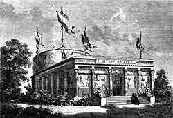 |
|
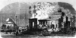
Outside view of the Suez Isthmus pavilion (Carnavalet Museum)
(©Photothèque des Musées de la Ville de Paris/Degraces) |
There is a small round edifice at the end of the building fitted
rather like an apse onto the nave of a church. It is a small
deviation from the rectilinear Egyptian architecture but all will
soon be explained.
At the door, your eyes are immediately drawn to a square pillar
made of a semi-transparent material. It is a block of rock salt
cut from the bottom of the Bitter Lakes of the Suez Isthmus. If
it had not been for the difficulty of transporting it, it could
easily have been twice or even three times as big, as the layer
of rock salt is so thick that they used to sculpt obelisks from it.
You go in and find yourself in a huge room lit from above and
whose temperature, when the sun shines in at the windows, cannot
be far from what was warming Mr de Lesseps workmen. A maharie,
a white-haired racing camel, and very artistically stuffed, completes
the local colour. Along the walls and in the windows are arranged
examples of the small flora and fauna of the country, shells from
the two seas, some fossil remains and a few small examples of
antique art found when digging the canal. In the middle of the
room, on a wide table, there is a model of the Suez isthmus, a
strange yellow slash between the two azure seas.
Here and there, a few thin patches of green colour the sand; arid
dunes undulate along the plain on the side of the Red Sea and
cross that valley of Wilderness where the Tribes of Israel wandered
after their exodus from Egypt. The Suez Isthmus forms a kind of
dip between Africa and Asia, where the hills gradually flatten out to become almost
imperceptible slopes.
 |
|
Moreover, this tongue of land which connects two continents is only thirty
leagues long - a mere snippet. In pre-history, the Mediterranean
and the Red Sea must have been connected. At least
one end of the Red Sea must have stretched into the Bitter Lakes since deep layers
of salt and thick silt are to be found there. |
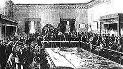
Mr de Lesseps gives a lecture on the Suez canal which will be
open in two years
(L'Illustration) |
|
This weak obstacle, this thin strip of ground only just visible
on the map, has, for centuries, forced vessels to sail towards the South
Pole right around
the continent of Africa. The distance was so great that to the nations of Europe, India and China
semed to be at the end of the world - the Far East was so far away that
people almost didn't believe in it. But it was not always like this. Sesostris
had the idea of joining the two seas by cutting the isthmus. But he dug his canal from the Pelusian branch of the Nile near Bubaste
to near Arsinoe on the tip of the Arabian gulf. This
canal, started by Sesostris and continued by Necho, Darius I
and Ptolemy Philadelphus, was finished under the first of the
Lagides; it was about two hundred kilometres long and ten metres
deep and two triremes could pass along it side by side. Despite
having to be frequently de-blocked it lasted until the eighth
century when Caliph Al-Mansur ordered the opening to be blocked
in order to stop trade with Baghdad. Traces
of the canal can still be seen although it is now full of sand.
Sesostris’ idea was taken up again by Mr F. de Lesseps and achieved
using the power of modern science. This gigantic project, conceived
in 1844, is already no longer just a project. The dream is becoming
reality. Only three tasks remain: a few kilometres need to be excavated on the
El-Guisr plateau; the Serapeum has to be pierced; and the narrow band separating
the extreme south of the Bitter Lakes from the tip of the Suez
gulf must be dug. It is a job of two or three years, and then vessels
will pass from one sea to the other through the ‘Bosphorus’ made
by human hands.
A similar operation on the Panama isthmus, that thread holding
together North and South America and blocking the passage from
the Atlantic Ocean to the Pacific Ocean, will allow man to circulate
freely around his globe, eliminating useless, enormous, detours.
We must do this soon because the planet has to be organised for
the future, a future which although as yet unknown can be fairly accurately
predicted, judging from great scientific discoveries which are
the honour of our century.
 |
|
But let us leave these thoughts, which are not suited to the passing
frivolity of a stroll around the Universal Exhibition, and let
us get back to our model. To the curious who enter the room, it
presents itself as to a traveller arriving from India.
|
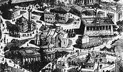
General view of the Egyptian Park of the Universal Exhibition
of 1867: from left to right: the Suez Isthmus pavilion, the Egyptian
Viceroy’s palace and the ancient temple.
(©Jean-Marcel Humbert) |
|
In front of you, to the North, you have the Mediterranean, and
to the left, a section of Lower Egypt, cultivated and green, where
the Nile, on its approach to the sea, divides up into branches
and disappears into its delta like the top of a palm tree. Towns
and villages mark this fertile region. To the right spreads the
arid plain, dotted with sand hills, which the canal cuts through.
Here reigns the scorching dryness of the desert and there would
not have been anything else to drink except sweat, had it not
been for the fresh water canal dug by the company. It goes from
Zagazig and brings Nile water as far as Timsah which is nearly
the half-way point of the maritime canal. The Suez Isthmus canal
starts from the Gulf of Peluse and the first blow of the pickaxe
broke the narrow line of sand where Port Said now stands, a completely
new town created specially
for the works of the company. The canal crosses Lake Menzaleh,
a type of marsh or lagoon created by an overflow of the Nile and
extending along the coast. A thin line of sand stretching as far
as Damietta separates the stagnant water from the salt water.
The bank rising from the canal forms an embankment which will
soon dry the Eastern point of the lagoon where the old Peluse
is, so preventing flooding from the Nile from reaching beyond
it.
There are more models on other tables representing different sections
of the canal and showing the powerful machines which now replace
the fellahs. There are dredgers, chutes (a cross between
sloping bridge and a steel roller coaster, designed for dumping the earth - torn from the bottom of the canal - as far as possible from the
banks), lighters, tugboats
and many sorts of amazingly specialised machines, all reproduced
to such a scale that none of the detail is lost and ranged along this blue
ribbon bordered by two banks of yellow sand.
| On the side walls there are photographs showing the different
aspects of the land and the work being done on the isthmus. Two
paintings - one by Berchère and the other by Barry - show a striking
contrast. In one you can see the isthmus in its natural state,
scorched, beaten, barely spotted with any vegetation at all, and
a picturesque barbarian caravan crossing the scene. |
|
 |
|
The Universal Exhibition of 1867. The foreign enclosure, the Egyptian
temple, the mosque and the palace of the Viceroy of Egypt.
(Musée Carnavalet)
(©Photothèque des Musées de la Ville de Paris/Degraces) |
In the other, we see the arrival of a boat for the first time
in the deep hollow of the canal in the presence of a crowd of
managers and engineers. The Company, which is aiming at communicating
to the public the importance and difficulty of the work, have
provided not only plans in relief, models of machines and photographic
views, but have also - in the rotunda placed at the very end of
the building - built a panorama of the isthmus which through the
astute use of the magic of perspective gives an uncanny impression
of reality. The panoramic view was painted by Messrs Rubé and
Chaperon from drawings by M. Chapon the Company’s architect.
To get to the panorama you climb to the upper platform which is
covered with canvass. Here you pass down a dark corridor. And
when you suddenly emerge, the viewer is immediately struck by
the sky (azure turning white from the intensity of the light).
You’re straight-away transported to steamy Africa. It is as if
beads of sweat are suddenly trickling down your temples after
you have disembarked in Port Said from one the Messageries impériales
boats. But this voyage can be completed in a much shorter time.
 |
|
In the corner on the right (since the panorama is not completely
circular) you see Port Said and the waters of the Mediterranean
merging into the horizon. On the left you see the waves of lake
Menzaleh, with its sandy beaches and myriad small islands stretching
down the coast of Africa.
|
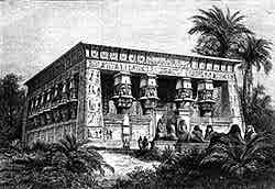
The Egyptian Temple: the Universal Exhibition of 1867
(Musée Carnavalet)
(©Photothèque des Musées de la Ville de Paris/Ladet) |
|
You can also make out the port under construction, the blocks
of cement lying out in the sun to dry before being submerged in
the harbour, the white sails of the merchant harbour and, on the
other side of the canal which spills into the sea, Port Said itself,
the houses ranged along the banks of the canal. Lake Menzaleh
swallows up the canal as it enters - all that marks its passage
is the two banks made with the earth removed during the excavations.
A canal entering a lake as if it were passing between two brick
walls is a strange thing in itself, but it is not the strangest
of the elements in this gigantic construction. It represents a
stretch of 45 kilometres - something which the panorama of course
abbreviates. In one part we see the encampment at Al Quantara
with its double rows of huts, its hospital on a rise and its swing
bridge crossed by the Syrian caravans.
The canal leaves Lake Menzaleh and heads for the dry land - but
not for long, for soon it reaches Lake Ballah, an irregular defile
which over the years has either been abandoned or filled with
water. Here the land rises up and forms a sort of barrier and
it is called the sill of El Guisr. This sill had to be cut to
allow the canal to pass through. We see the village of Ismailia,
the director’s residence, and like a silver thread heading for
fertile Egypt, there is the freshwater canal whose waters feed
a new town. On the left the scorched, sterile sands stretch in
dusty dunes towards Syria. Near to Ismailia, you can see the Arab
village with its bazaar and mosque. The fact is, that in painting
their panorama, Messrs Rubé and Chaperon have had to forget real
proportion and to give more importance to certain points of note
and to limit the amount of space given to the desert parts, which
being so similar would have merely filled up large parts of the
canvas to no good end.
| The Serapeum - for such is the name of the piece of land which
prevents the Red Sea from entering further down the isthmus -
did not stop M. de Lesseps. The canal plunges through this part
down to the Bitter Lakes, a vast dry basin, a valley of greyish
blue, sparkling with salt and other deposits. |
|
 |
|
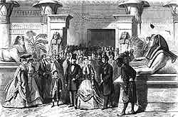
The Universal Exhibition of 1867
Their Imperial Majesties and the Viceroy of Egypt visiting the
temple of Edfu
(Le Monde illustré ) |
In certain parts of the basin the deposits have taken on the forms
of ruined villages or dilapidated fortresses.
This vast bowl holds the vast number of 900 million cubic metres
of water, and a whole year will be required to fill it with sea
water - this is planned for when all the construction work is
finished. One last obstacle faced de Lesseps’s men preventing
them from reaching the Red Sea - a ridge of exceptionally hard
stone, stretching several kilometres in the Chalouf region and
which had to be dynamited to create the appropriate gap. After
this there is the Suez plain at the feet of the djebel Genessé
and the last hillocks of the Attaka. The encampments of the Company
workers stretch picturesquely across the sand and next to this
the railway line, a thing line of metal, smoke streaming from
the smoke stack at the front, passing from Cairo to Suez.
The whole of this corner of the panorama is superbly coloured.
We see how the sun catches sand dunes, how the light catches a
dark cloak, how azure and amethyst shadows contrast with golden
and pink lights. Thus revealed, the ‘skin’ of the planet has the
shining of a star, such as the earth must look in the sky when
viewed from the moon.
When one leaves the rotunda, one gets the impression of having
made the journey to the isthmus, of having passed from one sea
to the other on the sort of steamboat which will soon make the
direct trip from Marseilles to Calcutta.
Théophile Gautier (1811-1872)
|