André Heughebaert wrote the programs designed to manage the databases and generate the visuals of the movements of the various military units on digital maps, and also built the website for the project, as well as his own blog, http://scriptogr.am/andrejjh. Eric Iven was responsible for creating the databases from historical references, and writing the website content describing his work. The maps available on the site JunIBIS resume the positions of the various units of the armies involved.
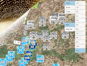
Three types of map are available: static maps which show the positions of units at fixed moments; dynamic maps where units move around from hour to hour; place maps show the locations of the various positions of the units.
So far, the project is being promoted by the website of the editions of La Belle Alliance, the tourist offices of Wavre and Namur, (the two new Napoleonic cities that start this year as well as several villages in Wallonia), the “Route armée Grouchy,” as well as the Fondation Napoléon.
Irene Delage: How did this project come about and what were your objectives?
André Heughebaert: It began with a surprising observation: “How come an event of this magnitude [the Belgian Campaign of 1815] which has been the subject of thousands of books is so little and so poorly mapped? “Our goal is above all educational: to make the conflict more understandable, more directly accessible to non-experts and particularly to the younger generation which is avid for new media. We wanted to make the movements of the various armies – Anglo-Allied Prussian and French – during the 1815 campaign available to everyone. In addition, we want to propose a bridge between two professions which far too often seem to ignore each other: historians and computer scientists. Finally, we want to make our own contribution to the memorial of this key period in the history of our country and of Europe.
Irene Delage: I suppose your first decision was whether to use historical or contemporary maps, what was your decision and why?
André Heughebaert: This was a very difficult choice and so we decided to offer both possibilities! The contemporary digital map gives the advantage of being able to situate oneself in the existing landscape and therefore to be able to follow a Napoleonic route while “visualising” the positions of the troops. The proliferation of smartphones makes this type of map all the more precious. It also responds to the phenomenon of “it happened in your back yard!”. Throughout history Europe has been a vast battlefield and hundreds or thousands of armies have descended upon her like clouds of locusts to devastate everything. Now that Europeans can legitimately enjoy peace in Europe (but nothing is ever written down in stone!) they can look at these tragic events with the necessary detachment and distance.
It is fun and interesting to find out for example that one lives in what was the location of a bivouac of 10,000 British soldiers! How many students of the University of Louvain-La-Neuve know that 80,000 Prussian soldiers once wandered around their campus and even fought there? Similarly, each aircraft taking off from Charleroi Airport crosses the path of the Uhlans of von Lutzow pursued by the first French hussars… The dynamic map which, by definition, shows an animation, uses a simplified contemporary map because it allows, among other things, a greater readability of the movements of the armies. The map most commonly used by the etats-majors in 1815 appears to be the one by Capitaine and Chanlaire (published in 1795) and/or the card “chorographic” by Ferraris. Both maps, considered from our contemporary viewpoint, are very basic (some experts have even pointed out the errors of these staff maps that may have had a significant impact on the course of the fighting. The French état-major systematically got muddled between the two farms, Mont-Saint-Jean and La Haye Sainte) or compared to the map by Count Ferraris which is very detailed. Ferraris's map, unavaiable to the 1815 contemporary as the only three existing maps were then in Vienna, is first and foremost a wonderful work of art; in full colour and extremely detailed, it allows us to put the fighters in their historical context and in a landscape very close to that of June 1815. It seemed interesting therefore also to show the movements and fighting in this context. Today's maps are of course much more precise and contain a wealth of touristic or historical information. That explains why the majority of the maps in the Junibis project are based on the map of Ferraris.
Irene Delage: How did you decide which sources and historical information to use as references?
André Heughebaert: The project started with a huge handicap: neither of us is a historian. So we were completely unaware of the methodology to be applied to this project, of which the selection of sources was a key element. So in the beginning, we felt a bit like we were searching “in the dark” …
So I asked myself, “What do you need to know for this project to succeed? “. And using a fairly Cartesian logic, the answer came quickly: We needed to know: 1. Which military units were present at the events and who was in command 2. Where they were located and 3. at what time they were there. In the end, it was simple, three small questions!
To which I could add two other questions which we needed to answer: 4. How did people lived during the 1st Empire? 5. and: How did they make war?
I was not so naive as to believe that it would be easy. So one day, a publisher friend offered to help me. The aim was to identify the movement of a particular battalion at the Battle of Quatre Bras. He provided a part of the sources. I complimented them with mine. What a nightmare! Reading everything, trying to match the various testimonies took me… eight hours. For one battalion! And even then the results were rather limited with regard to the accuracy of certain facts. Fortunately for us, we also had some strong points. Firstly… 50 years of Napoleonic reading. At the age of 5 years (time flies!) I read “Napoleon” by Raymon Duprez (Nouvelle édition pour la jeunesse), and ever since, I have been constantly enriching my knowledge on the subject… reading, re-reading in English, in French and in German everything I could get my hands on. I was therefore not starting from scratch, having read at least once the entire Napoleonic bibliography before starting. In addition I had under my belt 23 years practice of historical gaming, during which I had simulated several times the battles of Quatre Bras, Waterloo, Ligny, Wavre, and the attack on Plancenoit.
Finally, there is an incredible amount of information available on the Internet. A number of foundations, organisations and even federations share not only articles but also make maps available. And today it is now possible to access via internet rare works that were previously inaccessible. They must be confronted with the latest publications on the subject. Like any historical subject, explanation of facts evolves over time. There is everything out there: from simple propaganda to nationalistic glorification as well as revisionism. It is striking to see that the latest publications on the subject are critical vis-à-vis the narrative of the nineteenth and early twentieth centuries. These latest publications were my guide for the choice of sources, since they were both critical and very comprehensive.
So unfortunately I have not myself been to the Château de Vincennes in Paris or the Musée Royal de L'Armée in Brussels to peruse the shelves, since I just didn't have enough time, though I wish I had! Others have done this job for us, and we trust them. The most useful things we found and which responded immediately to questions 1, 2 and 3 above were obviously the maps and atlases. There are the obvious ones such as the map of Craan for the Battle of Waterloo. But the majority of maps date from the Nineteenth Century and the positions of troops have often been questioned by modern authors. In particular the maps of Siborne (History of the War in France and Belgium, in 1815) are gorgeous … but contested. Many of these atlases and maps have been studied carefully and are cited in the references.
The newly-published maps (21st Century) are rare and sorely lacking in detail. Why? Simply because it is a very difficult exercise. Technically in the minds of most people, it remains difficult to make a map. It is an exercise that takes time, and is therefore expensive. And a map is very effective, an error can be detected immediately. Few authors are ready to face criticism. It is easier to write, for example (as I have read many times): “It is late afternoon when the English cavalry burst out of the crossroads, and shortly after turned left along the road… “remaining rather vague: what exactly does “burst out” mean?
Finally it is clear that on the basis of the sources consulted it is simply IMPOSSIBLE to describe precisely what happened in the campaign of 1815, every five minutes.
A certain humility is essential in this type of exercise. We believe we are presenting each situation with a margin of error of more or less two hours for the chronology and more or less two kilometres for the position. After all, we have created a database of more than 10,000 entries.
Irene Delage: You explain in your blog that one of the three founding principles of your project is open data, can you explain this?
André Heughebaert: The three founding principles of our project are: free and open data, and referencing of sources.
As in many areas, the digital revolution is accompanied by a change of paradigm. In the past, information was still compartmentalised, reserved for an elite and often reproduction was prohibited, unless explicitly permitted. Today, information travels at the speed of the Internet and data holders wish to open information to the greatest number. The traditional copyright of authors (often very restrictive) are seeing themselves overtaken by sharing licenses (less restrictive). Many scientific fields have already made a step in this direction, history is no exception to this rule.
Our maps are therefore under CC-BY license that allows anyone “to copy, distribute, display and perform the work and make derivative works based on it only if they give the author or licensor the credits in the manner specified by these” and indicate any changes.
Thus freeing our maps for further possible uses we hope to encourage other similar initiatives and, who knows, prepare for future collaborations.
June 2015