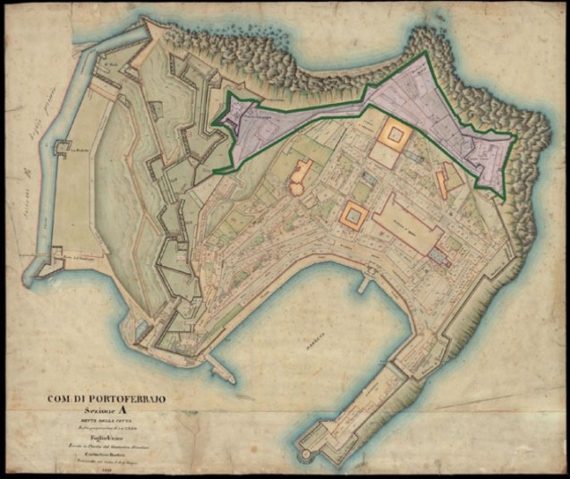
This cadastral map of Portoferraio (entitled COM: DI PORTOFERRAJO, Sezione A, detta della città Foglio Unico) comes from the extremely important corpus of 19th-century cadastral maps created before the great urban transformations which occurred in Tuscany at the end of the nineteenth century. Indeed, this corpus is of fundamental importance for the reconstitution of the pre-19th-century state of the region. The map was drawn from the cadastral survey that was begun under Napoleon in 1808 and which lasted until the fall of the Empire, a survey which served as a model for the creation of the “Nuovo catasto dei territori del Granducato di Toscana” (New cadastral survey of the territories of the Grand Duchy of Tuscany) which the “restored” Ferdinando III di Lorena commissioned from a deputation in 1817.
In 1826 the ‘General views’ were created from the parcel surveys, and the cadastral record was in place in the period between 1832 and 1835.
The islands of the Tuscan Archipelago were not part of this initial cadastral operation since they were not subject to land tax. As a result, the cadastral survey for them took place in the period from 1840 to 1845. These plans constitute the first ever scientific cartographic representation of the area and as such provide precise and very detailed information.
This map in particular made it possible to get precise measurements for the “Napoleonic compartition”, a zone which as can be seen occupied almost a fifth of the city of Portoferraio.
Also clearly visible are the still extant fortifications protecting Napoleon’s residence and the complex of buildings reserved for the Household or Maison.
Also see: Fortifications, Island of Elba. Plan of Portoferraio, An 10, dating from 1802.