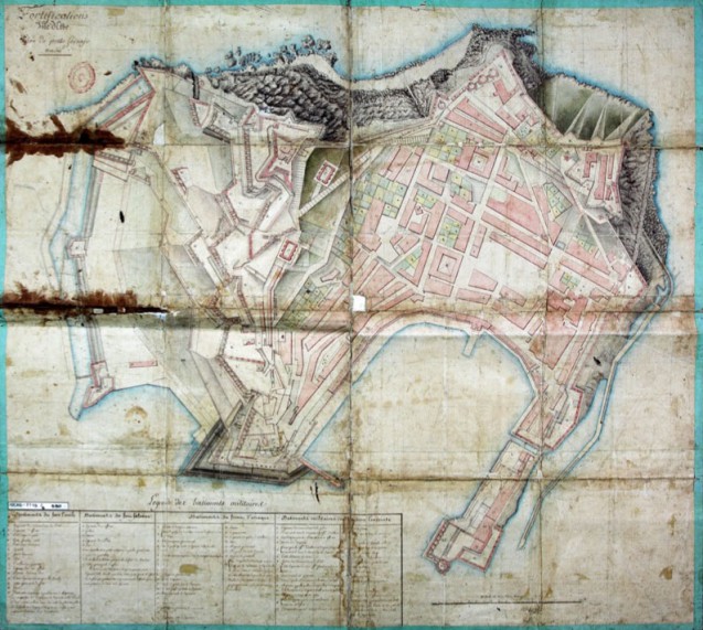
This plan of Portoferraio (entitled “Fortifications, Isle d’Elbe. Plan de porto ferrajo, an. 10”), made in 1802 by Baron Charles Humbert Marie Vincent, first Director of Fortifications on the island of Elba, shows all the military buildings in the city, noting those related to Forte Stella and those connected to Forte Falcone, giving also the defensive fronts both outside and within the fortified city. Of particular interest is the I Mulini bastion zone, an area which would be completely transformed as a result of Napoleon’s direct intervention.
Here are shown all the buildings which twelve years later, the Emperor would demolish so as to turn this military fort into the place of his residence.
To the top left can be seen the four windmills and the building which, when partly demolished, would become the imperial theatre. The small outbuildings around the main structure were to be removed in order to create the formal gardens, and the old prison was to be demolished to make way for stables to house the eight cousins or chevaux du rang (state horses) that Napoleon brought with him to Elba, namely, Ingénu (also known as Wagram), Intendant (pet named Coco) and Tauris, who had accompanied Napoleon to Russia and who would go with him back to Paris for the Hundred Days.
Buildings not demolished were those of the Pavillon south of the main residence, already destined to house the officers and kitchens attached to the Convento di San Francesco, which the French transformed into a military garrison in 1803.
Vincent in his Memorial de L’Ile d’Elbe ou détails sur l’arrivée et le séjour de Napoléon dans l’Ile d’Elbe written in Portoferraio in 1814 recounts in detail all the places which he had visited – often at dawn – with the Emperor throughout the island. Napoleon had known Baron Vincent for several years since he was to note to the Commissioners of the Allied Powers on board the frigate which brought him into Portoferraio bay on 3 May, 1814: “The Colonel Vincent is the man who best judged events. I made some serious mistakes in not listening to him, and I would not be here if I had known that better”.
Also see the Cadastral map of Portoferraio, Elba, dating from 1841.